During 3 month, between 07 of February and 10 of May we are going to Budapest in Hungary as an Erasmus Student.

Our university is Óbuda University.

We need to validate 5 subjects to obtain all our 15 ECTS (Introduction to procedural and SQL programming, PHP Web programming, Networking practice, Introduction to IT Service Management, Business English)
The website of our University: http://www.uni-obuda.hu/en
Geography:
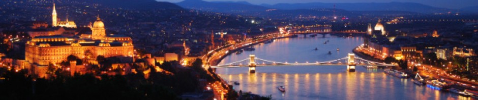
The city’s importance in terms of traffic is very central, because all major European roads and railway lines lead to Budapest. The city is divided into two parts by the Danube in a north-southerly direction. The hilly left bank is called Buda, with over 20 hills within the territory of the capital, and the plain right bank is called Pest.
Buda is generally a recreational and residential zone, with industrial areas only far away in its southern and northern parts, while Pest gives home to massive housing, commercial and industrial areas.
There are 3 islands on the Danube within Budapest. The Csepel Island, whose northern tip protrudes into the capital, the historical Margaret Island, and the Óbudai Island in the North. The Szentendre Island, which is to the North from the capital, reaches all the way up to the Danube Bend.
Budapest is the only capital city in the world which has thermal springs. Some 125 springs produce 70 million litres of thermal water a day, with temperatures ranging up to 58 Celsius. Some of these waters have medicinal effects due to their medically valuable mineral contents.
There is a remarkable cave system, formed by the thermal waters, under some of the hills in Buda. The most extensive one is right underneath the Castle Hill. These have been used for hundreds of years, and they proved especially useful during wars and invasions.
Information about Budapest :
Area: 525 sq km (52516 ha), 2/3 of its territory falls to plain Pest and 1/3 to hilly Buda
Population:1 690109 people (about 17 % of the whole population of Hungary)
Population density: 3219 p/sq km
Religions: Roman Catholic 45%, other Christian 18%, unaffiliated 19%, Israelite 0,5%
Ethnic groups: Hungarian, Roma, German
Length (N-S): about 25 km (15 miles)
Width (W-E): about 29 km (18 miles)
Lowest point: the surface of the Danube (96m above sea level)
Highest point: János-hegy (529 m above sea level)
Climate: temperate; cold, cloudy, humid winters; warm summers; the number of sunny hours exceeds 2000 yearly, and the average temperature is 11 C°
Time zone: GMT +1 (CET)
National flag description: three equal horizontal bands of red (top), white (middle) and green (bottom)
Administration: 23 districts (the Roman numbers indicate the district)
Tipping: accepted at 10% rate in restaurants, at the hairdresser’s, for taxi and other services
Holidays:
- 1 January – New Year’s Day
- 15 March – National Holiday – the anniversary of the revolution against Austrian rule
- 8-9 April – Easter
- 1 May – Labor Day
- 27-28 May – Whit Monday
- 20 August. – National Holiday – St. Stephen, the Hungarian state founder’s day
- 23 October – National Holiday – commemorating the outbreak of the 1956 revolution against Soviet rule
- 1 November – All Saints’ Day
- 25-26 December – Christmas
How to go there ?
By plane :
It’s very easy to get to Budapest by plane – several low-cost airlines and also the national airline have great offers and services.
By train :
There are 3 main international railway stations in Budapest: Eastern (Keleti), Western (Nyugati) and Southern (Déli). More than 50 trains a day provide direct links between Budapest and 25 other European capital cities. Trains to Vienna run every 3 hours, 7 times a day. There is also a popular network of Inter City trains linking Budapest with the main Hungarian towns. All three international railway stations are part of the Budapest Underground system, the Metró.
Public transports in Budapest:
Public transportation: BKV buses, trams, 3 metro lines, HÉV (suburban railway), cogwheel railway; other interesting means of transport: ferry boats, the Budavári sikló (Buda Castle Funicular), gyermekvasút (Children’s Railway) and the Zugligeti libegő (Zugliget chairlift)
Main railway stations: Nyugati (Western), Keleti (Eastern), Déli (South) and Kelenföldi pályaudvarok
Airports: Ferihegy International Airport with 3 terminals 15km from the city centre: Ferihegy 1 receives discount airlines, Ferihegy 2A terminal is for planes within Shengen area, terminal 2B is at the disposal of the non-Schengen airlines.
Accommodation:
It is really easy to find a flat in Budapest. I give you some links:
http://www.only-apartments.fr/
Good plans:
Free walking tour:
The route planner helps you to organize your trip. You just need to indicate where would you like to start and where would you like to travel. The website chosen the best way to go at your destination.
http://utazastervezo.bkv.hu/tervezo/index.php?lng=eng
Sources: http://www.budapest.com/
If you want, click on the link below to watch our presentation of Hungary.

I was just seeking this information for some time. After 6 hours of continuous Googleing, at last I got it in your site. I wonder what’s the lack of Google strategy that don’t rank this kind of informative websites in top of the list. Normally the top websites are full of garbage.